REDISCOVERING WANSTEAD HOUSE - Mobile Phone Audio Guide - PART 1

INTRODUCTION
This guide is designed to be used on a smart phone with an internet connection. Best using the Safari browser on an iPhone and Chrome on an Android phone.
This guide is designed to be used on a smart phone with an internet connection. Best using the Safari browser on an iPhone and Chrome on an Android phone.
The guide consists of direction instructions (written in black) which lead you on a set route to various places in Wanstead Park. Once at these places, there are audio recordings that explain the historical significance of what you can see there.
There is also an accompanying online map (see below). You can use this if you need help to find the places to listen to the audio guide at.
You can click on the red letters on the map to find out what that position is.
The walk is divided into sections, denoted by colours, so that you can choose to do just parts of the walk if you wish. Scroll down if you are starting from the beginning (Park Road, London E12) or click on the underlined titles to jump to the section that you want.
PARK ROAD TO THE REPTON OAK
(Historical overview, the Reservoir, the Repton Oak)
(Historical overview, the Reservoir, the Repton Oak)
SECTION 2 (ORANGE)
THE REPTON OAK TO THE CHALET
(The Shoulder of Mutton Pond, the Heronry Pond, the Chalet)
THE REPTON OAK TO THE CHALET
(The Shoulder of Mutton Pond, the Heronry Pond, the Chalet)
THE CHALET TO THE GROTTO
(The Roman finds, The Temple, The Gamekeepers Cottages, The Grotto back)
THE GROTTO TO THE GLADE
(The Grotto front, the Straight Canal, the Fortification and Amphitheatre, the Mounts, the Glade)
SECTION 5 (PURPLE)
THE GLADE TO ST MARY'S
THE GLADE TO ST MARY'S
(The Wanstead House stables, St Mary the Virgin Church, the crypt, and the site of the medieval church, some interesting graves, and the view of the site of Wanstead House)
The walk starts at the Park Road entrance to Wanstead Park. Park Road leads off the Aldersbrook Road next to St Gabriel's Church (E12 5HH). Buses W19 and 101 stop at Park Road.

SECTION 1 (RED)
PARK ROAD TO THE REPTON OAK
PARK ROAD TO THE REPTON OAK
(An historical overview, the Reservoir, the Repton Oak)


This is at map position (A)
A SHORT HISTORY OF WANSTEAD HOUSE (AND PARKLANDS)
(Click the play button below)


CONTINUE THE WALK... along the path, and walk over an earth bridge over a drainage trench, which (when full) flows into the Shoulder of Mutton pond, then turn immediately left (see photo below).


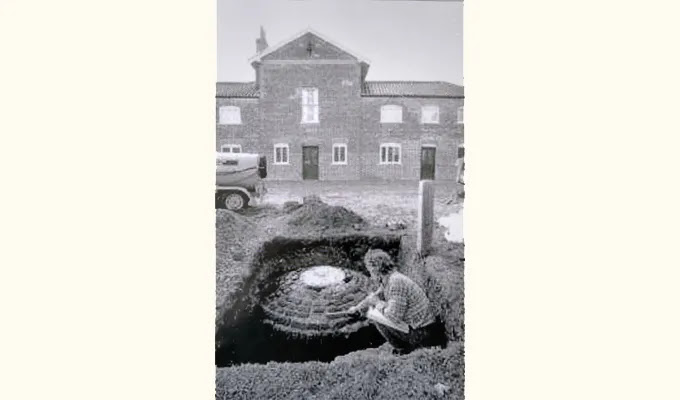
This is at map position (B)
THE RESERVOIR
(Click the play button below)

CONTINUE THE WALK... by climbing over the reservoir bank, straight ahead is the Repton Oak (see photo below).

THE REPTON OAK
(Click the play button below)
(The Shoulder of Mutton Pond, the Heronry Pond, the Chalet)

Walk on until you come to a pond on the right. This is the Shoulder of Mutton Pond. It is the pond that you were standing on the other side of when listening to the Brief History of Wanstead House and Park.

(Click the play button below)

CONTINUE THE WALK... along the path until you reach the Heronry pond on your right. Over the pond on the right you can see the Wanstead Park tea hut (see picture below).
 This is at map position (E)
THE HERONRY POND
(Click the play button below)
Above: Wanstead has had a long connection with Herons. This is the modern day coat of arms of Wanstead and Woodford

CONTINUE THE WALK... along the path. After a while, a broad path appears going left, which follows the edge of the golf course. Ignore this path, and instead go straight ahead through a gap in the concrete fence (see picture below).


THE CHALET
(Click the play button below)

CHALET TO THE GROTTO
(The Roman finds, The Temple, The Gamekeepers Cottages, The Grotto back)
Link to online map (if needed)
Back to sections menu
STAY WHERE YOU ARE... but look over at the land to the right of the Temple towards the modern day tea hut. This area has been the focus for looking for the remains of Roman occupation of the area.
ROMAN FINDS IN THE PARK
(Click the play button below)
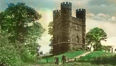
MOVE A LITTLE TOWARDS THE TEMPLE...

This is at map position (G)
THE TEMPLE(Click the play button below)

Image from British Gentlemen at Sir Horace Mann's Home in Florence (circa 1765) by Thomas Patch. Public Domain, from the Yale Center for British Art, Paul Mellon Collection.
CONTINUE THE WALK... Move around to the other side of the Temple, and look at it from the opposite side where you can see the Gamekeeper's Cottages. There are toilets here if you need them.

(Click the play button below)
CONTINUE THE WALK... along the path past the back of the temple, keeping the trees on your left, and with the open area on your right.
Where the path veers to the left, and the Ornamental Water lake is ahead, take a smaller path bending to the right over the grass ahead. Soon you will get to the back of The Grotto. Walk a little to the right to get a better view through the fence of the rear of the structure (see picture below).

BACK OF THE GROTTO
(Click the play button below)

Above: A photograph of the inside of the Grotto. The walls were encrusted with shells and crystals and the floor mosaiced.

GROTTO TO THE GLADE
(The Grotto front, the Straight Canal, the Fortification and Amphitheatre, the Mounts, the Glade)
Link to online map (if needed)
Back to sections menu
CONTINUE THE WALK... by following the path around to the front of the Grotto, and stand behind the sign about fishing. Play the next audio recording here, looking at the front of the Grotto.

This is at map position (J)
FRONT OF THE GROTTO
(Click the play button below)
CONTINUE THE WALK... along the same path, until you get a view to the right of the Straight Canal (see picture below).
Recently, the Straight Canal and the Ornamental Water have dried out, so there may not be much water in it. To check that you are in the right spot, immediately behind you will be the Glade, a long strip of grassland with trees on each side.

THE STRAIGHT CANAL
(Click the play button below)


STAY WHERE YOU ARE... but look along the path to the left (when looking towards the water) to where the Ornamental Water continues along on the right, and play the next audio recording. The view should look like the photo below.

(Click the play button below)

 Above: The positions of the Amphitheatre and the Fortification in relation to the Glade and the Straight Canal.
STAY WHERE YOU ARE... but turn left again and look up the Glade. Play the next audio recording here. The view should look like the photo below.

(Click the play button below)
CONTINUE THE WALK... and start walking up the Glade, ignore the first single path on the left, and after about 180 metres away from the Straight Canal, look out for two paths, one on each side of The Glade. These are facing each other and leading into the trees. There is a good view down the Glade of the Straight Canal from here.
Each of the two paths, lead to a ‘Mount’, which are small man-made hills. We will find the larger of the two.
Find the path on the right (when looking up the Glade), and walk into the trees here. See picture below, which shows the path leading off The Glade towards the Mount.

You will soon come to some Yew trees planted on the left, in a large circle around the Mount. Go left through the Yew trees, move ahead, and you will start to glimpse the Mount ahead, through the heavy undergrowth. Move a short distance anticlockwise around the Mount to find a steep pathway up it (see picture below with the arrow indicating the path).

This is at map position (L)
THE MOUNT
(Click the play button below)

Above: The red rings mark the two mounts, either side of the Glade and surrounded by formally laid out gardens.
CONTINUE THE WALK... by returning to the Glade, turn right and walk a little way up.
This is at map position (M)
Nearing the top, have a last look down towards the Straight canal. It's this view, which would have been seen from the rear of the spectacular Wanstead House, which helps support the suggestion by some that it was "The English Versailles".
Carry on up the Glade, and take the right hand path to walk towards the Warren Road entrance.

(The Wanstead House stables, St Mary the Virgin Church and crypt, the site of the medieval church, some interesting graves, a view of the site of Wanstead House)
Link to online map (if needed)
Back to sections menu
CONTINUE THE WALK... by exiting the park at the Warren Road entrance. Walk along Warren Road, and then turn first left on to Raynes Avenue. At the end of Raynes Avenue, turn left on to The Warren Drive, which will bend to the right.
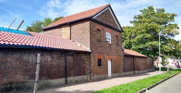
Just before The Warren Drive ends, walk up a small earth bank into Wanstead Golf Course car park. Walk on to the entrance to the golf club courtyard.
This is at map position (N)
WANSTEAD HOUSE STABLES
(Click the play button below)

CONTINUE THE WALK... go to Overton Drive, which runs outside the Golf Club. Turn left, and continue to St Mary the Virgin church, a short way along. Enter the churchyard and pause in front of the church.
This is at map position (O)
ST MARY'S CHURCH
(Click the play button below)


Above: The entrance to the crypt.

Above: The Crypt. On the right is a picture of the jar containing the heart of John Child, second Earl Tylney. Thanks to Caroline Barkus for the image.
CONTINUE THE WALK... and walk on the path that goes along the right side of the church. As you get to the rear of the church, turn right along the path. On the right hand side, you will see some large memorial slabs on the ground. See the picture below to check that you are in the right spot.

THE SITE OF THE MEDIEVAL CHURCH
(Click the play button below)


CONTINUE THE WALK... by walking further down the path until you come to the rear of the Watcher's Box, a tall white stone structure on the right. Walk around to the front of this memorial.

This is at map position (Q)
SOME INTERESTING GRAVES
(Click the play button below)


CONTINUE THE WALK... and return to the path near to the Watchers Box. Turn right and continue down the path. On the left, over the wall, is the first glimpse of where Wanstead House was. You can see a long deep depression in the ground which is where the Wanstead House cellars were.


THE SITE OF WANSTEAD HOUSE
(Click the play button below)


Public Domain image. Original Painting held by the Philadelphia Museum of Art.

Above: Catherine and William Pole-Tylney-Long-Wellesley
Public Domain images.
END OF WALK
The nearest tube station and buses are at Wanstead. Walk down St Mary's Avenue, straight on outside the churchyard, for around 550 metres.
Please send your feedback!
Let us know if you enjoyed the walk, and if you have any other feedback that we could use to improve it.
Music used in the audio recordings on this page:
Sonatina No 2 in F Major Allegro - Joel Cummins - Copyright Free Music - YouTube Audio Library
Camille Saint-Saëns: Danse Macabre by Kevin MacLeod - Free Music Archive